Log in
All resources
Create a design
9,296 Free Artworks of Map Collection
bibliothèque nationale de france
eran laor cartographic collection
latin-language maps
paper
british museum
dutch-language maps
maps in the british museum
british library
joan blaeu
engraving on paper
eran laor cartographic collection
baroque
eran laor cartographic collection
philippe de la rué
eran laor cartographic collection
alain manesson-mallet
eran laor cartographic collection
claes jansz. visscher (ii)
eran laor cartographic collection
johannes van den aveelen
eran laor cartographic collection
claes jansz. visscher (ii)
portrait of sebastião josé de carvalho e melo, 1st marquis of pombal by louis-michel van loo and claude joseph vernet
paintings by joseph vernet
maps of the west-indische compagnie
1747 maps
a map of the british empire in america with the french and spanish settlements adjacent thereto
1730s maps of the caribbean
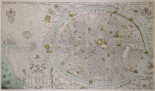
maps of dresden by braun & hogenberg
maps of leipzig by braun & hogenberg
18th-century maps of corsica
maps by thomas kitchin
a new map of the island of tobago... - by tho.s kitchin... - btv1b53121990k
maps by thomas kitchin
a new map of the island of tobago... - by tho.s kitchin... - btv1b53121990k
maps by thomas kitchin
the british monarchy (1743)
maps in the british museum
maps in the british museum
maps of kensington gardens
1690s maps of baden-württemberg
1690s maps of alsace
1620s maps of the netherlands
maps by pieter van der keere
old maps of vermandois
maps by gerard valck
the british monarchy (1743)
maps in the british museum
old maps of vermandois
maps by gerard valck
maps of vangiones by sanson
maps by nicolas sanson
1668 maps of south america
maps by guillaume sanson
1660s maps of france
maps of le mans
17th-century maps of crete
old maps of candia
maps of alsace by guillaume sanson
1690s maps of alsace
maps of the islands of greece by marco boschini (1658)
old maps of skiathos
1890s maps of czechia
czech-language maps
1770s maps of the world
1775 maps
1620s maps of the netherlands
maps by pieter van der keere
the british monarchy (1743)
maps in the british museum
maps of spain by tomas lopez
1765 maps of spain
maps from university of amsterdam special collections
atlas der neederlanden
maps of paris from the david rumsey historical map collection
environs de paris levés géométriquement by jean delagrive
maps by alexis-hubert jaillot
old maps of the tyrol
antoine-françois tardieu
maps from gallica
1870s maps of the atlantic ocean
the bottom of the sea (1870)
media contributed by university of illinois urbana-champaign university library
1631 maps of africa
maps in the stadsarchief amsterdam
hendrik de leth
maps of barbary coast by mercator-hondius
maps by jan janssonius
maps of ancona by braun & hogenberg
maps in the british museum
geographia universalis (1545) in the british museum
german renaissance,northern renaissance
het zegepralent kennemerlant
hendrik de leth
maps of country estates in the netherlands
het zegepralent kennemerlant
media contributed by university of illinois urbana-champaign university library
carte du mexique et de la floride by guillaume delisle (1703)
paintings by joos van craesbeeck
baroque
st thomas's church, monmouth
welsh landscape collection
claes jansz. visscher (ii)
atlas van stolk
praefectura paranambucae pars borealis, una cum praefectura de itâmaracâ
1647 maps of brazil
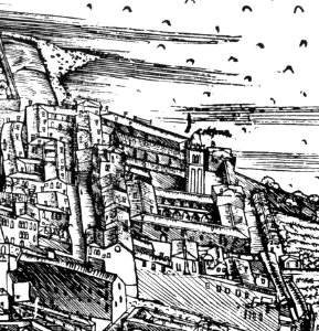
demolished churches in de barbari map
chiesa della celestia
maps from university of amsterdam special collections
atlas der neederlanden
maps from university of amsterdam special collections
atlas der neederlanden
maps by johannes vingboons
old maps of kochi, kerala
atlas maior, vol 2 (sweden, russia, poland, eastern europe, and greece) - joan blaeu, 1667 - bl 114.h(star).2
magni ducatus lithuaniae
maps of the west-indische compagnie
1747 maps of africa
maps of the west-indische compagnie
1747 maps of africa
eran laor cartographic collection
johann martin will
1680s maps of rhineland-palatinate
maps of vangiones by sanson
maps by pieter mortier
maps from gallica
maps by louis brion de la tour
1782 maps of the caribbean
maps of spain by tomas lopez
old maps of menorca
maps by pieter mortier
maps from gallica
1760s maps of the philippines
baroque painting
18th-century maps of north africa
maps by tomas lopez
maps of france by hendrik hondius
17th-century maps of xaintonge
maps by willem and johannes blaeu
collections of limburgs museum
1779 maps of the united states
1770s maps of the caribbean
media from atlas of mutual heritage on dutch east india company
1650s maps of indonesia
17th-century engravings
johannes de ram
eran laor cartographic collection
pieter schenk (ii)
eran laor cartographic collection
gottfried hensel
eran laor cartographic collection
willem blaeu
eran laor cartographic collection
romeyn de hooghe
eran laor cartographic collection
german renaissance
eran laor cartographic collection
william henry toms
maps from university of amsterdam special collections
atlas der neederlanden
david rumsey historical map collection
maps of basel by braun & hogenberg
beschreibung der städt der welt - braun & hogenberg - btv1b52512111k
maps of konstanz by braun & hogenberg
plantae yucatanae. (regionis antillanae)
1903 in yucatán
carte de moscovie by guillaume de l'isle (1706)
1700s maps of russia
beschreibung der städt der welt - braun & hogenberg - btv1b52512111k
maps of lisbon by braun & hogenberg (1572)
maps by nicolas sanson
maps from gallica
beschreibung der städt der welt - braun & hogenberg - btv1b52512111k
maps of burgos by braun & hogenberg
beschreibung der städt der welt - braun & hogenberg - btv1b52512111k
maps of cusco by braun & hogenberg
caribbean maps in leiden university library
files uploaded at wiki techstorm 2019
cartouches by alexis-hubert jaillot
maps by guillaume sanson
caribbean maps in leiden university library
files uploaded at wiki techstorm 2019
robert gordon of straloch
1650s maps of scotland
old maps of lazio
henry le roy
map of bruges by marcus gheeraerts (i)
drawings in the groeningemuseum
maps of guinea by mercator-hondius
eran laor cartographic collection
media contributed by university of illinois urbana-champaign university library
1830 maps of africa
media contributed by university of illinois urbana-champaign university library
1830s maps of egypt
bibliothèque nationale de france
sanson map of lorraine
1575 illustrations
1575 prints
geographia universalis (1545) in the british museum
german renaissance,northern renaissance
british library - off the map alice collection - wonderland
british library - off the map alice collection
1876 paintings
academic art
atlas maior, vol 8 (france ii and switzerland) - joan blaeu, 1667 - bl 114.h(star).8
1667 maps
atlas maior, vol 10 (spain and africa) - joan blaeu, 1667 - bl 114.h(star).10
1667 maps
atlas maior, vol 1 (northern europe, norway, and denmark) - joan blaeu, 1667 - bl 114.h(star).1
1667 maps
3601 - 3700 of 9,296
Next page
/ 93